Tiwanaku Temple Hiding in Plain Sight Rewrites Maps in Bolivia

On a windswept Bolivian plain, archaeologists stumbled onto a temple where none should be—a massive Tiwanaku-style complex hidden beneath centuries of footsteps. The discovery redraws the frontier of a vanished empire and reveals how religion, trade, and politics once converged on sacred ground.
A temple where no temple should be
Palaspata, southeast of Lake Titicaca, looks ordinary: tawny steppe, scattered shrubs, a worn track cut by herders and hooves. Yet that track bisects the perimeter of a lost monument. For generations, locals unknowingly walked straight through Tiwanaku’s forgotten geometry.
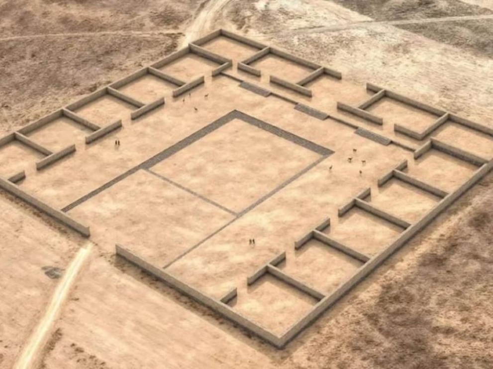
The red sandstone wall they crossed is now confirmed as the outline of a temple the size of a city block—410 by 475 feet—with 15 modular rooms wrapped around a sunken courtyard. Its monumental entrance faces west, precisely aligned to capture the light of equinox sunsets.
The architecture is textbook Tiwanaku: terraced platforms, recessed courts, ordered modules. Its precision left scholars startled. No previous record placed such fidelity to the Tiwanaku style this far south. “We don’t expect it in this particular place,” one researcher admitted, astonished that such a temple should exist beyond the heartland.
That astonishment only grows with context. Palaspata sits beside what is today the La Paz–Cochabamba Highway, a modern artery that echoes ancient trade routes. The same corridor once carried llama caravans bearing salt, textiles, and dried meat goods that knit together highland communities and enriched the Tiwanaku state.
Who the Tiwanaku were—and why this matters
Long before the Incas built their stone cities, Tiwanaku rose on the reed-lined shores of Lake Titicaca. It was one of the Americas’ first great states: a society of administrators, artisans, and farmers bound together by sacral politics.
The cold, thin air of the altiplano was inhospitable to maize. Tiwanaku answered with ingenuity—raised fields that captured warmth, canals that stored moisture, and caravans of llamas that stitched together distant communities. Rather than rule by military garrisons, Tiwanaku projected its power through shrines, way stations, and ceremonial nodes. Belief and bureaucracy reinforced one another; feasting on chicha, the maize beer brewed for rituals, cemented loyalty across distances.
Until now, scholars assumed Tiwanaku’s reach stopped closer to Lake Titicaca. Palaspata rewrites that assumption. Sherds of classic keru cups—tall beakers for chicha—have surfaced at the site. Their presence, alongside the equinox alignment, suggests this was a gathering place where scattered groups renewed bonds in shared ritual.
Strategically, Palaspata sits at the hinge of two highland zones—a vantage point to monitor caravans, tax goods, and translate ritual prestige into political leverage. In short, it is precisely the kind of “Gateway Temple” a soft-power empire would build at its margins.
Stones, sunlight, and a digital resurrection
The rediscovery of Palaspata came not through accident but through technology. While mapping a nearby site, archaeologists noticed a faint rectilinear ridge. They walked it, flew drones over it, and built 3D models. Slowly, the plan of the temple emerged from light and shadow.
The red sandstone blocks—local, luminous at dusk—drew lines on the plain that, once rendered, revealed a striking plan: a west-facing gate aligned to solar cycles, a sunken court for ritual focus, and a collar of rooms likely used for officials, storage, or musicians whose rhythms carried ceremonies deep into the night.
The track that cuts through the compound adds irony to the tale. For centuries, villagers and herders trampled unknowingly across sacred ground. Sandals, hooves, and wheels etched movement over stone long buried by dust. That casual crossing now feels like a metaphor for Tiwanaku itself: a powerful past hidden beneath everyday life, threaded invisibly into Bolivia’s geography.
Imagine the equinox centuries ago: the sun sinking into the western notch, shadows lengthening across sandstone, the courtyard filling with chant and drum, keru cups raised high. Ritual, politics, and belonging fused in one intoxicating moment—an empire renewed with every sunset.
José CaprilesPenn State
Rethinking collapse, rethinking the map
Tiwanaku’s fall remains an open debate. Some blame drought, others ecological strain, others social unrest against elites who fused cosmology with control. Palaspata cannot settle that argument, but it complicates it. Outposts like this would have been the first to feel the stress: caravans thinning, storehouses empty, festivals dwindling until silence replaced music.
Yet even as it hints at collapse, Palaspata expands the known reach of Tiwanaku’s prime. It forces scholars to look beyond the Titicaca Basin and into Bolivia’s mid-Andean highlands for more shrines and way stations. It shifts the image of Tiwanaku from an isolated capital to a lattice of ceremonial hubs that bound distant communities.
The discovery also challenges modern expectations of what a “real” state should look like. Early archaeologists looked for palaces, armies, and terraced valleys bursting with maize. Tiwanaku confounded them because it built differently: through ritual circuits rather than conquest, llama caravans rather than legions, horizons and sunsets rather than fortresses.
Also Read: Chilean Huemul Comeback Hints at Hidden Herds Across Patagonia
On a windswept plain south of Titicaca, Palaspata has given Bolivia another piece of that puzzle. A temple hidden beneath footsteps has reemerged, carved in sandstone and aligned with the sun. It is not only a rediscovered ruin—it is a reminder that entire empires can hide in plain sight.


