Colombia and Peru Navigate Rising Tensions Over a Shifting Amazon Island

Under the dense humidity of the Amazon basin, where the river’s surface hides slow but constant change, Colombia and Peru are now locked in a dispute over a patch of land that wasn’t even here a century ago. Born from the river’s restless current, the island has become a diplomatic flashpoint—one where hydrology meets history, and sediment stirs political waters.
From Lawmaking to Street-Level Friction
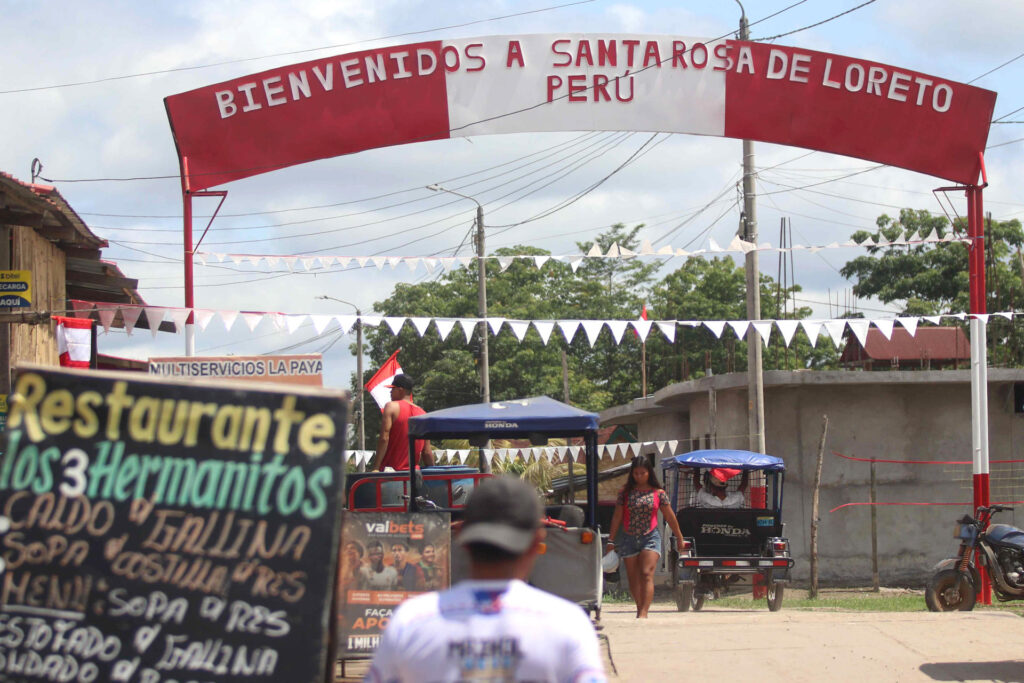
The latest flare-up began on June 12, when Peru’s Congress unanimously approved the creation of the District of Santa Rosa de Loreto in the country’s Loreto region. The district’s capital, Santa Rosa, sits just across the river from Colombia’s Leticia. But the legislation, published in El Peruano on July 3, defined jurisdiction in a way that, from Bogotá’s perspective, swept in territory never formally assigned to either nation.
Colombia’s reaction was swift. On June 20—and again on the very day the law appeared in print—it lodged diplomatic protests, urging the reactivation of the Comisión Permanente de Inspección de la Frontera (Comperif), a bilateral body meant to handle precisely these kinds of issues. The Foreign Ministry insisted the so-called Santa Rosa island emerged after the 1929 allocation of islands and “has not been assigned to Peru,” stressing that only mutual agreement could settle such a matter.
Peru’s reply, issued the next day, dismissed the Colombian claim outright. Lima reaffirmed what it called its “legitimate rights of sovereignty” and argued the area had long been under Peruvian administration. On August 5, Colombian President Gustavo Petro escalated matters by accusing Peru of “appropriating territory that belongs to Colombia,” prompting an equally firm retort from Peruvian President Dina Boluarte.
Treaties Anchored in an Unstable River
The dispute’s legal roots stretch back more than a century, to the 1922 Salomón–Lozano Treaty. This “Treaty on Borders and River Navigation” fixed the boundary along the Amazon River’s thalweg—the line that follows the deepest navigable channel—until the river meets the Brazilian frontier. Ratified in 1928, it was mapped in detail the following year by a joint demarcation commission.
As former Colombian foreign minister Julio Londoño Paredes explained to EFE, “A river always has a deeper channel where ships navigate to avoid running aground. In the Amazon, that deeper channel was defined in 1928 and mapped in 1929.” The commission’s principle was simple: any island in the river would go to the country whose shore was nearest.
That process is assigned to the Colombian islands, such as Zancudo No. 2, Loreto, Santa Sofía, Arara, Ronda, and Leticia; and to Peru, including Tigre, Coto, Zancudo, Cacao, Serra, Yahuma, and Chinería. The last of these, Chinería, is key to Lima’s argument today—Peru claims the disputed formation is physically attached to it. Bogotá counters that Santa Rosa is distinct, formed by sediment accretion long after the allocation.
Echoes of an Old Conflict
The tension inevitably recalls the 1932–1933 Colombia–Peru conflict, triggered when Peruvian civilians and soldiers seized Leticia. The brief but bitter war ended with the 1934 Rio de Janeiro Protocol, which reaffirmed the Salomón–Lozano Treaty. It bound both nations to resolve disputes through diplomacy or arbitration, never force.
Now, both sides are invoking that history to justify their stances. Petro calls Peru’s district law “a unilateral act” in breach of bilateral commitments. Peru responds that the territory in question has been Peruvian in practice for decades, with no previous objection from Colombia. In Santa Rosa, daily life has continued much as before, with trade, family ties, and river traffic crossing invisible lines in the water.
But the stakes are more than symbolic. Colombia’s Leticia is its only port on the Amazon’s main flow. Any change in the river’s course—or the interpretation of its navigation channel—could have strategic and economic consequences, shrinking Colombia’s window to the Atlantic via the Amazon.
When the River Writes Its Borders
The problem is that while treaties remain frozen on paper, the Amazon is anything but. Since at least the 1970s, sedimentation near Leticia has shifted channels, spawning new landforms and subtly moving the navigable route. What was once open water can, in a matter of years, become a sandbank or an island—an uncharted piece of territory with the potential to alter local control.
To Bogotá, Santa Rosa is one of several such formations, its status undecided and therefore subject to negotiation. To Lima, it is an extension of Chinería and thus clearly Peruvian. Between those positions lies the challenge of reconciling static maps with a river that rewrites itself in silt every wet season.
Also Read: Colombia’s Streets Erupt as Uribe’s Supporters Turn Verdict Into a Rallying Cry
The first formal attempt to untangle the issue is scheduled for September 11–12, when the Comperif meets in Lima. Whether that meeting produces a technical survey, a diplomatic compromise, or only more public posturing remains to be seen. In the meantime, the island—born of water and mud—stands as a reminder that in the Amazon, nature’s changes can ripple through treaties, politics, and national pride.


