Colombia’s Escarabajos Vanish from Tour Mountains That Forged Their Legend

Colombia did not merely lose the Tour’s polka-dot jersey in 2026. The nation once feared as the unbeatable escarabajos vanished from the climbs that forged its legend, while Ecuador’s Richard Carapaz carried Latin America’s mountain inheritance into Paris without them.
The Jersey That Once Spoke Colombian
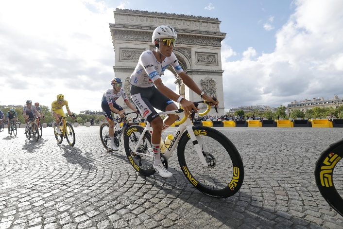
Einer Rubio was climbing toward the old Colombian dream when the road folded into panic. On Alpe d’Huez, with the crowd narrowing the asphalt and a high finish still possible, a spectator fell near a UAE support vehicle. The driver braked. Rubio struck the rear window face first. He left by helicopter, needed roughly 20 stitches, and abandoned the Tour with Paris only two days away. His race ended not because his legs failed, but because the mountain had become too crowded to contain its own theater.
For Colombia, the accident carried cruel symbolism. Rubio had been the one rider still producing flashes of the attacking escarabajo, the beetle who rises when the road tilts. Yet even before the crash, Colombians were not shaping the decisive climbing stages. They rode in the peloton and occasional breakaways but were absent from the defining images. They won no summit finish, placed nobody in the final top ten and never seriously contested the white jersey covered in red dots, the Tour’s King of the Mountains prize.
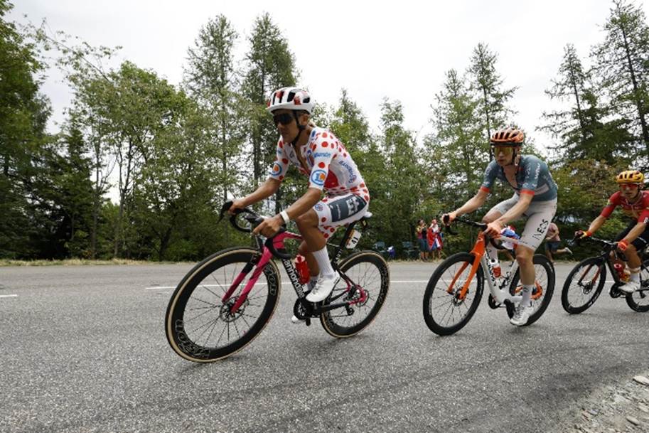
Richard Carapaz did. The Ecuadorian won Stage 18 at Orcières-Merlette, then conquered the queen stage on Alpe d’Huez two days later. He finished eighth overall, secured the polka-dot jersey and was named the Tour’s most combative rider. On the mountain where Rubio disappeared into an ambulance, Carapaz took command of the mythology. The transfer felt larger than a classification. A neighboring Andean nation had inherited the emblem that generations of Colombians taught Latin America to recognize.
The jersey was never merely fabric in Colombia. Its red circles became exported geography, small dots standing for páramo roads, coffee-country switchbacks and boys learning balance on bicycles too large for them. Luis “Lucho” Herrera won on Alpe d’Huez in 1984, the first South American to take a Tour stage. He captured the mountains classification in 1985 and 1987. Fabio Parra climbed onto the overall podium in 1988. Later, Mauricio Soler and Nairo Quintana kept the polka dots connected to Colombian altitude. Tour history itself describes the jersey as passing through generations of Colombian climbers.
That is why the 2026 absence cut so deeply. Colombia did not simply lose a shirt. It lost possession of a story it once authored. Herrera and Parra arrived when European cycling viewed Colombians as exotic amateurs who might animate a climb before fading. Their attacks transformed “escarabajo” from a quaint nickname into a threat. The polka-dot jersey became legendary because it offered recognition before yellow seemed attainable. It said Colombian legs could rule the highest ground.
When the Mountains Went Quiet
The final standings were not a catastrophe. Egan Bernal, the 2019 champion, finished 20th. Harold Tejada was 26th and Sergio Higuita 38th. Those are serious achievements, but maintenance results rather than nation-making ones. Fernando Gaviria left with a broken collarbone, and Rubio abandoned after Alpe d’Huez. Five starters became three finishers. None reached Paris carrying a stage bouquet, classification jersey or place near the podium.
The contrast with the rest of Latin America was vivid. Del Toro, only 22, finished third overall and won the white jersey as the Tour’s best young rider. The Mexican stood beside Tadej Pogacar and Remco Evenepoel in Paris, not as a novelty but as a plausible future champion. Carapaz supplied the mountain victories and red dots. Mexico owned youth and the podium. Ecuador owned combativeness and climbing. Colombia, the region’s historic cycling factory, owned memory, scar tissue and the question of what happened next.
The decline did not begin in 2026, but the previous Tour offered more resistance. In 2025, Santiago Buitrago finished third atop Mont Ventoux, and Rubio placed fifth on the Col de la Loze queen stage. Neither won, and Pogacar ultimately took the polka dots, yet Colombians still appeared in decisive mountain photographs. In 2026, even that consolation nearly vanished. Rubio’s attack ended in glass, and no compatriot replaced him near the front. This Tour did not create the drift. It stripped away much of the remaining visual evidence of Colombia’s old identity.
Money offers a colder version of the story. The four teams employing the five Colombian starters earned about €96,040 combined in Tour prize money. UAE Team Emirates-XRG, powered by Pogacar and Del Toro, collected €832,750. EF Education-EasyPost, with Carapaz’s stages, polka dots and aggression, earned €124,160. These are team totals, not national accounts, and the money is shared across riders and staff. Still, the gap measures visibility. Wins, jerseys and podiums convert sporting authority into cash, sponsor exposure and bargaining power.
A stage victory was worth €11,000 and the mountains classification roughly €25,000, but the real value sits beyond the purse. An Alpe d’Huez winner becomes television footage, contract leverage and a national reference. A domestique may ride heroically for three weeks and still vanish from memory. Colombian riders increasingly arrive as helpers, secondary climbers or stage hunters rather than protected leaders.
That distinction separates this generation from the age of Café de Colombia. Herrera and Parra were not lone exports scattered through European payrolls. They rode inside a project carrying a country’s coffee economy, colors and ambition. The team gave Colombians collective tactical freedom and converted national sponsorship into European access. Today’s riders may have better equipment, nutrition and sports science, but their objectives belong to multinational teams whose principal leaders come from elsewhere. Talent survives. Command has migrated.
Del Toro’s rise illustrates the new model. He won the 2023 Tour de l’Avenir and moved rapidly into UAE’s elite system, where enormous resources can turn unusual promise into Grand Tour readiness. His success does not mean Mexico has already built Colombia’s former production line. It means one extraordinary Mexican entered cycling’s most powerful accelerator. Carapaz’s route is equally revealing. The rider from Ecuador’s Carchi province developed part of his career in Colombia before moving to Europe. The succession is not a clean national replacement. It is an Andean circulation of roads, coaching and opportunity, with global teams collecting the best results.
Talent Remains, but the Pipeline Frays
The more troubling Colombian result occurred before the Tour began. Tour Colombia, the country’s most visible international stage race, was canceled for a second consecutive year because organizers could not secure the necessary financing. One missing race does not explain a lost polka-dot jersey. Two missing editions, however, reveal the fragility beneath the mythology. Domestic events create television hours, municipal contracts, sponsor relationships and rare moments when young riders can be seen beside WorldTour professionals without first reaching Europe.
Colombia still produces cyclists in astonishing conditions. Altitude remains. Cycling culture remains. Families still treat a bicycle as transport, livelihood and improbable escape. What has weakened is the bridge between raw ability and protected leadership. Regional clubs struggle for money. Races disappear or return unpredictably. Riders leave young and enter foreign hierarchies where survival often means carrying bottles, controlling breakaways and sacrificing personal results. The old system was imperfect and romanticized, but it placed Colombian ambition at the center of the plan.
Bernal’s 20th place should not be mocked. Neither should Tejada’s 26th or Higuita’s 38th. Rubio’s approach to Alpe d’Huez showed that the old instinct has not vanished. These men rode through crashes, fatigue, and team obligations that rankings barely register. The danger lies in confusing respect for their labor with satisfaction about the national system. Colombia did not fail because its riders lacked courage. It failed to arrive with enough riders empowered to turn courage into results.
Pogacar’s dominance narrowed everyone else’s possibilities. He won a fifth Tour and controlled the race with a team rich enough to place Del Toro on the podium beside him. Yet Carapaz still found room for two mountain victories and a classification jersey. That matters. It shows the Colombian blank was not simply produced by an unbeatable champion. Other goals remained available, the very goals that once built Colombian legends. Ecuador pursued them with clarity. Colombia mostly served, survived and mourned what might have been.
The country’s task is not to manufacture another Herrera through nostalgia. It is to restore the conditions that allowed many Herreras, Parras, Solers, Quintanas and Bernals to become imaginable. That requires stable races, serious youth development, domestic sponsors willing to stay beyond one political cycle, and teams capable of giving Colombian climbers leadership rather than ceremonial freedom. The mountains have not rejected Colombia. The road to them has become narrower.
In Paris, Del Toro wore white, and Carapaz wore the red dots. Colombia arrived without a jersey, stage win or top-ten rider, even after the climbing stages where its colors once multiplied with every hairpin. The nation that taught the Tour to fear the escarabajos is not gone. But in 2026, the legend climbed under other flags, while Colombia watched from farther down the mountain.
Also Read: Cuban American Quarterback Fernando Mendoza Bets Big on Vegas Glory


